Metti una bella giornata con un clima ideale, metti che hai voglia di panorami nuovi, perchè non provare uno di questi percorsi? Organizzati, chiama gli amici e scegliete insieme il tracciato che vi convince di più.
Cima Rovaia (2525 m)... tra Val Canè e Val Grande

TEMPO DI PERCORRENZA: ore 4,55
LUNGHEZZA PERCORSO: 31,9 km DISLIVELLO: 1714 m CICLABILITA': 10% - 100% |
Campodolcino - Pian dei Cavalli - Lago Bianco (2323m)

TEMPO DI PERCORRENZA: ore 4,00
LUNGHEZZA PERCORSO: 34,4 km DISLIVELLO: 1535 m CICLABILITA': 60% - 95% - 100% |
Albosaggia - Campelli - Pizzo Meriggio (2348 m)
|
TEMPO DI PERCORRENZA: ore 4,45
LUNGHEZZA PERCORSO: 30,4 km DISLIVELLO: 2086 m CICLABILITA': 5% - 99% - 100% |
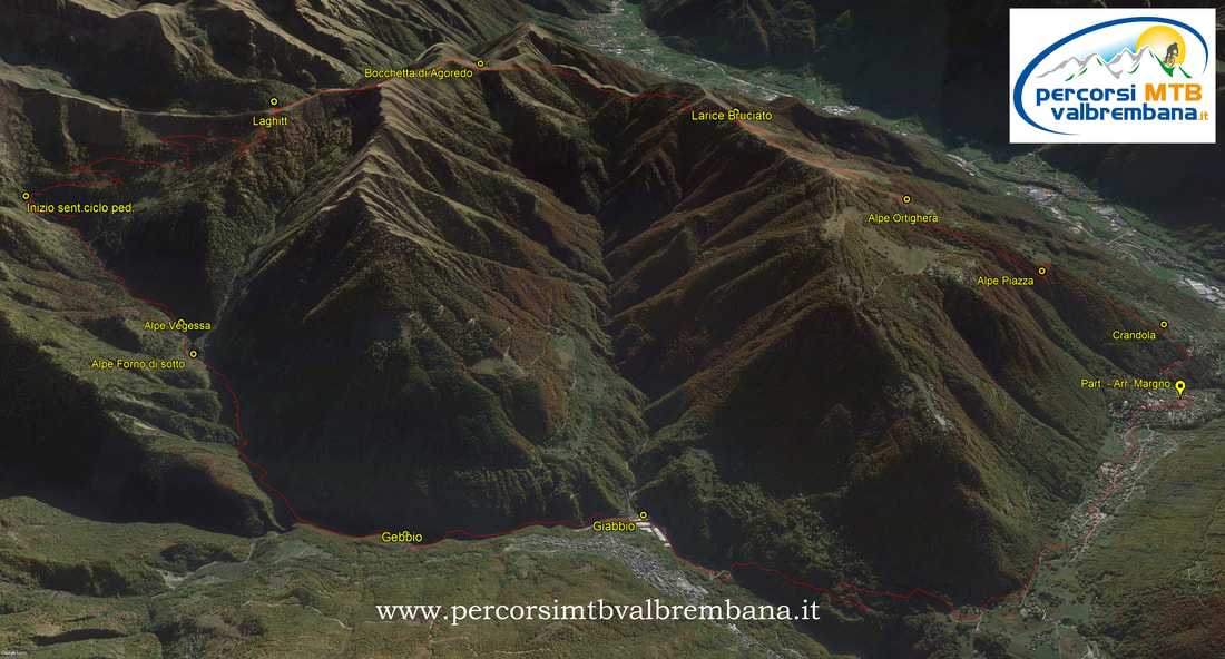
Albaredo - Rifugio Alpe Piazza - Monte Lago (2353 m)

TEMPO DI PERCORRENZA: ore 4,20
LUNGHEZZA PERCORSO: 21,0 km DISLIVELLO: 1485 m CICLABILITA': 0% - 99% |
Giro dei Forti al Passo del Tonale (Val di Sole)
|
TEMPO DI PERCORRENZA: ore 5,00
LUNGHEZZA PERCORSO: 44,7 km DISLIVELLO: 1650 m CICLABILITA': 100% |
Monte Berlinghera (1930 m)... balcone panoramico sui Laghi di Como e Novate Mezzola

TEMPO DI PERCORRENZA: ore 4,55
LUNGHEZZA PERCORSO: 27,8 km DISLIVELLO: 1772 m CICLABILITA': 0% - 95% - 100% |
Monte Zenone (1425 m) - Bocca di Fobia - Passo Nota
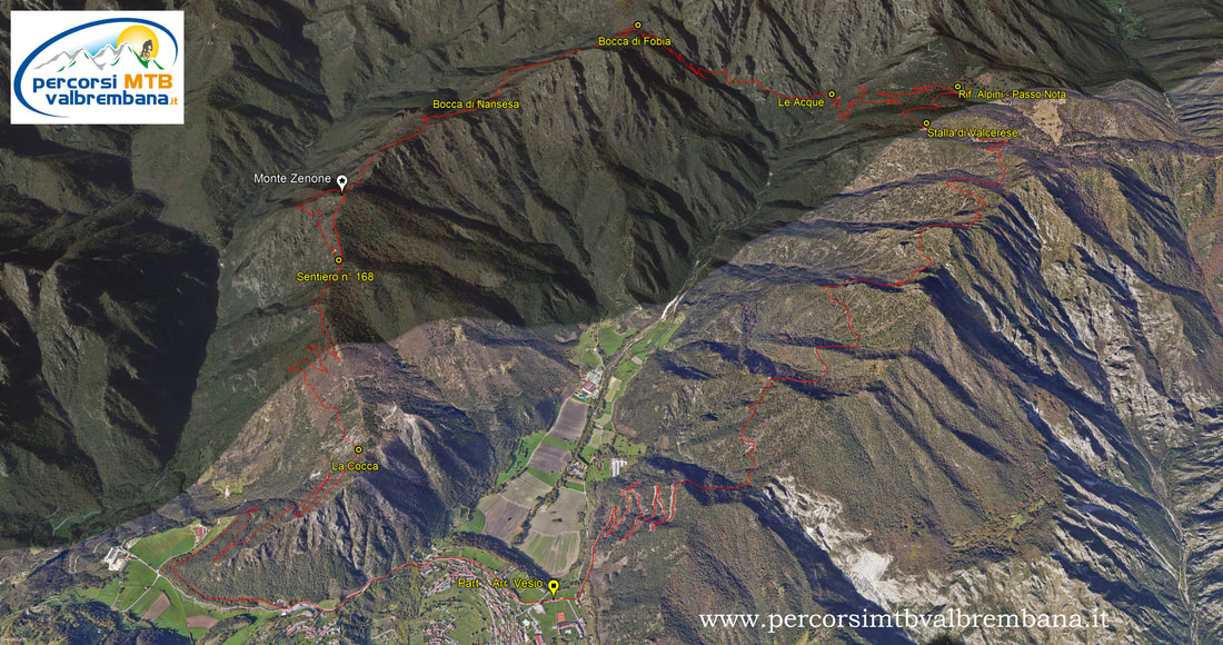
TEMPO DI PERCORRENZA: ore 4,30
LUNGHEZZA PERCORSO: 31,5 km DISLIVELLO: 1506 m CICLABILITA': 0% - 60% - 80% - 100% |
Da Canzo - M. San Primo (1682 m) - Conca di Crezzo

TEMPO DI PERCORRENZA: ore 4,40
LUNGHEZZA PERCORSO: 39,2 km DISLIVELLO: 1710 m CICLABILITA': 100% |
Piz Martegnas (2681 m) da Savognin - (CH)
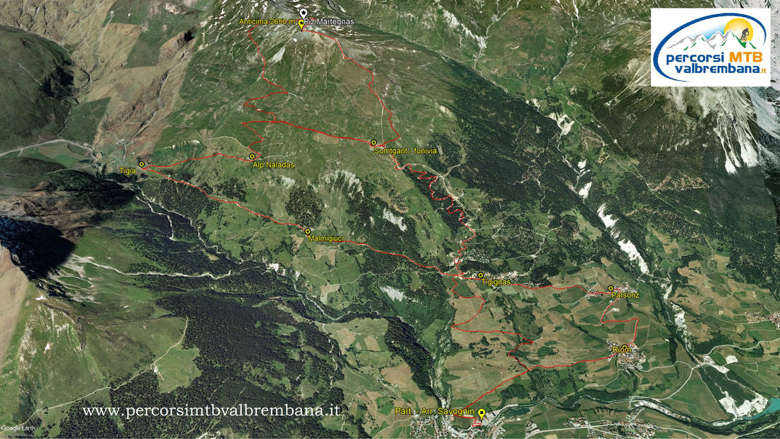
TEMPO DI PERCORRENZA: ore 4,00
LUNGHEZZA PERCORSO: 30 km DISLIVELLO: 1593 m CICLABILITA': 10% - 100% |
Blinnenhorn (3374 m) da Riale - Val Formazza
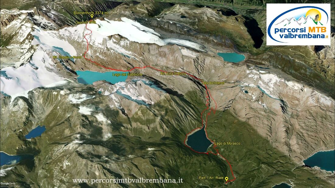
TEMPO DI PERCORRENZA: ore 6,10
LUNGHEZZA PERCORSO: 30,6 km DISLIVELLO: 1945 m CICLABILITA': 30% - 3% - 80% - 95% 100% |
Valsassina e Valvarrone - L'anello della Cornagiera
TEMPO DI PERCORRENZA: ore 3,50
LUNGHEZZA PERCORSO: 29,8 km DISLIVELLO: 1558 m CICLABILITA': 80% - 100% |
Dal Lago d'Iseo - Corna Trentapassi - Malga Aguina
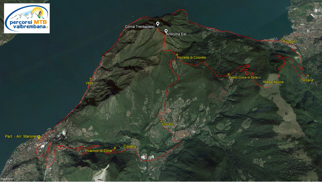
TEMPO DI PERCORRENZA: ore 4,00
LUNGHEZZA PERCORSO: 31,8 km DISLIVELLO: 1429 m CICLABILITA': 0% - 50% - 95% - 100% |
ValleRossa - Eremo S. Defendente - Tour del M. Clemo
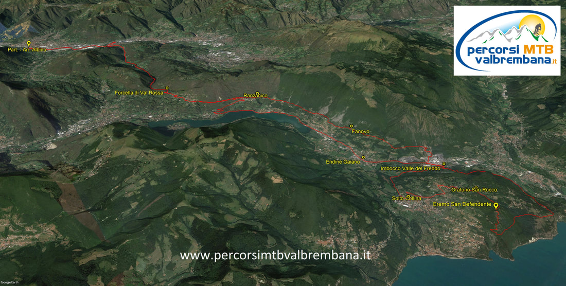
TEMPO DI PERCORRENZA: ore 5,00
LUNGHEZZA PERCORSO: 64,8 km DISLIVELLO: 1529 m CICLABILITA': 60% - 100% |
Dalla Valle dell'Adige - Monte Baldo - Punta Telegrafo
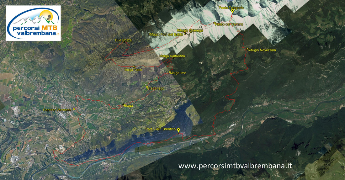
TEMPO DI PERCORRENZA: ore 6,35
LUNGHEZZA PERCORSO: 61,9 km DISLIVELLO: 2479 m CICLABILITA': 60% - 80% - 100% |
Dalla Valle di Zermatt... al cospetto del Cervino
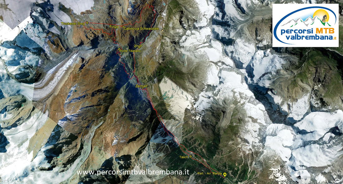
TEMPO DI PERCORRENZA: ore 4,40
LUNGHEZZA PERCORSO: 42,9 km DISLIVELLO: 1310 m CICLABILITA': 60% - 100% |
In sella nelle Prealpi Luganesi... da Rivera al M. Tamaro
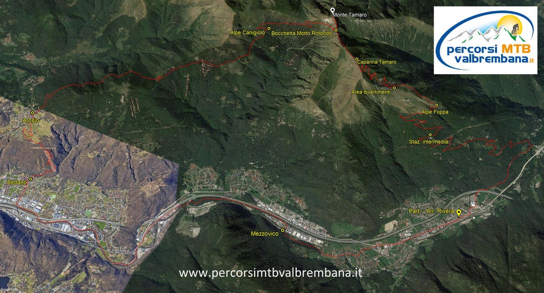
TEMPO DI PERCORRENZA: ore 4,50
LUNGHEZZA PERCORSO: 39,9 km DISLIVELLO: 1794 m CICLABILITA': 99% |
Edolo - Passo del Mortirolo - Monte Pagano 2346 m
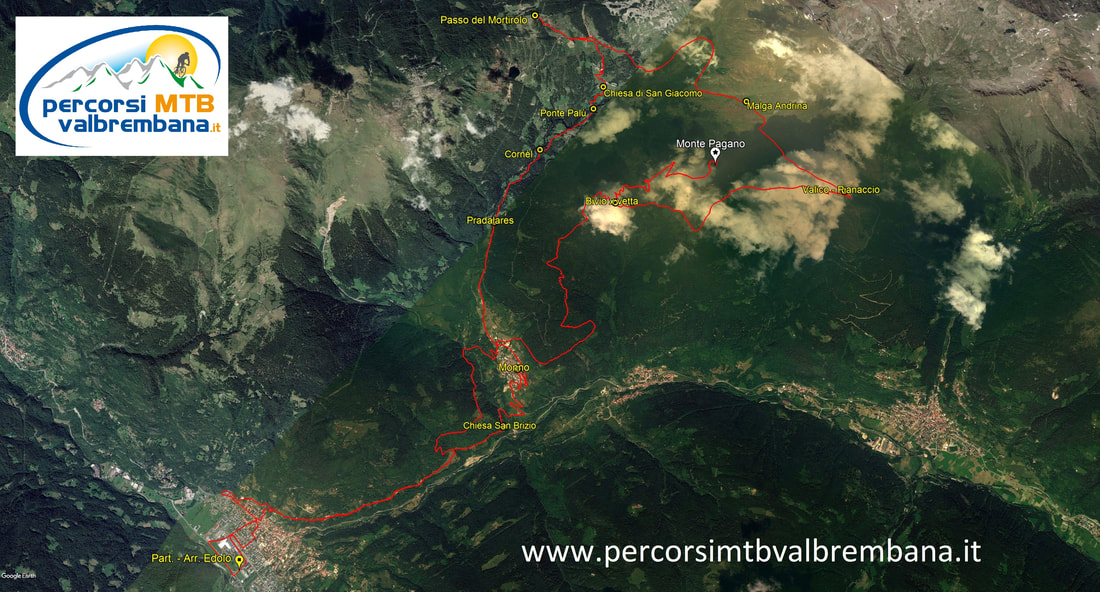
TEMPO DI PERCORRENZA: ore 5,30
LUNGHEZZA PERCORSO: 45 km DISLIVELLO: 1875 m CICLABILITA': 40% - 100% |
Da Lax - Fiescheralp - Aletsch Arena - Bettmeralp
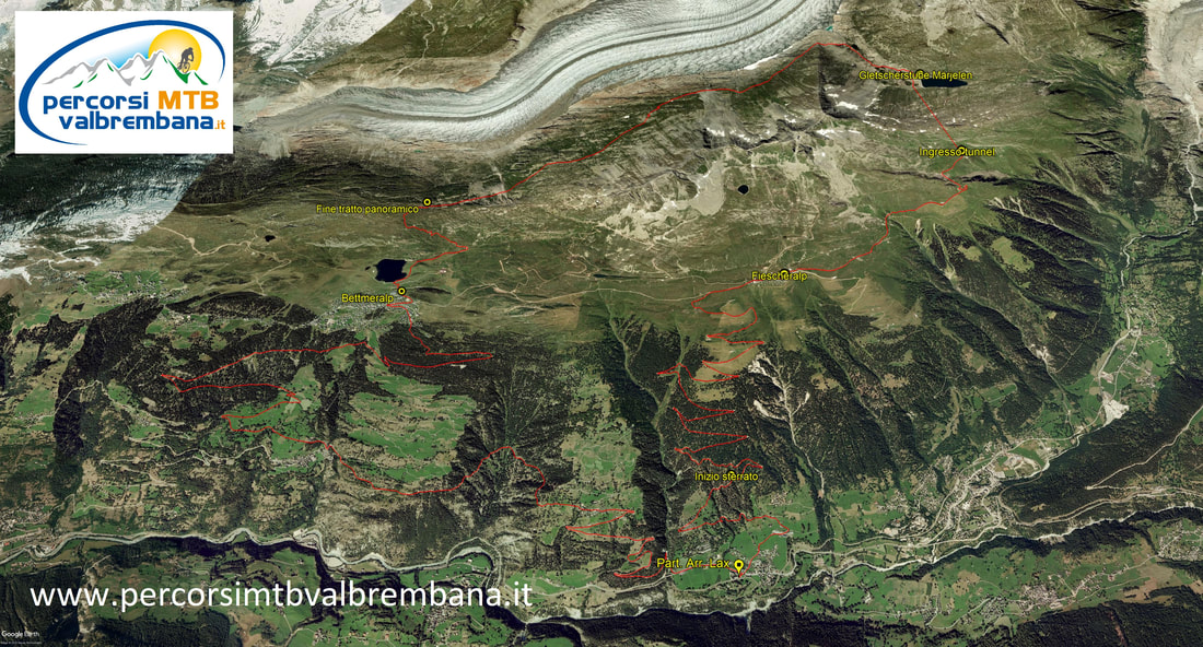
TEMPO DI PERCORRENZA: ore 5,00
LUNGHEZZA PERCORSO: 41,1 km DISLIVELLO: 1655 m CICLABILITA': 50% - 100% |
Val d'Intelvi.... fra i Laghi di Como e Lugano
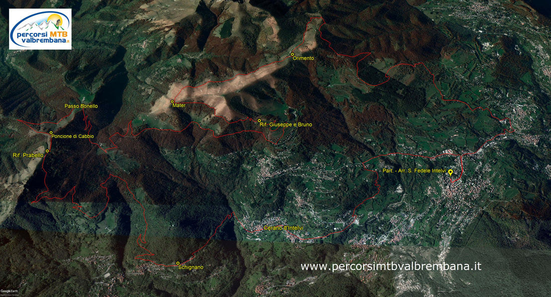
TEMPO DI PERCORRENZA: ore 4,45
LUNGHEZZA PERCORSO: 38,7 km DISLIVELLO: 1265 m CICLABILITA': 99% |
Vicosoprano - Val Maroz - Val da Cam (Val Bregaglia)

TEMPO DI PERCORRENZA: ore 4,15
LUNGHEZZA PERCORSO: 21,9 km DISLIVELLO: 1390 m CICLABILITA': 99% - 50% - 5% - 30% |
Riale - Val Toggia - Cap. Corno Gries - Passo del Gries
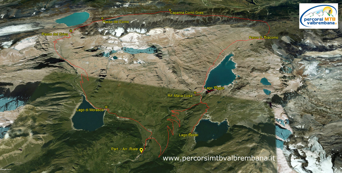
TEMPO DI PERCORRENZA: ore 4,15
LUNGHEZZA PERCORSO: 29,3 km DISLIVELLO: 1045 m CICLABILITA': 50% - 70% - 100% |
Simplon Dorf - Passo Sempione - Spitzhorli 2737 m
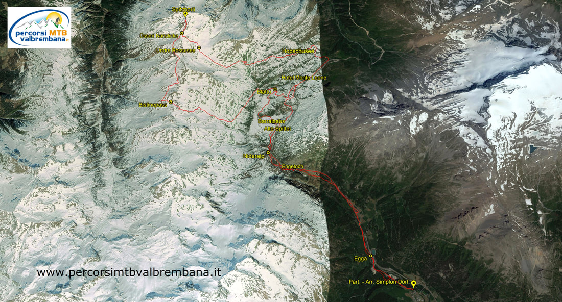
TEMPO DI PERCORRENZA: ore 4,55
LUNGHEZZA PERCORSO: 32,3 km DISLIVELLO: 1320 m CICLABILITA': 40% - 99% |
Dalla Val Trompia: Montecampione - Monte Cimosco
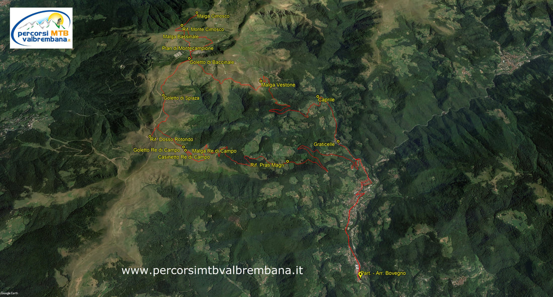
TEMPO DI PERCORRENZA: ore 4,30
LUNGHEZZA PERCORSO: 33,7 km DISLIVELLO: 1365 m CICLABILITA': 99% - 30% - 0% |
Grande anello dell'Alta Val Trompia
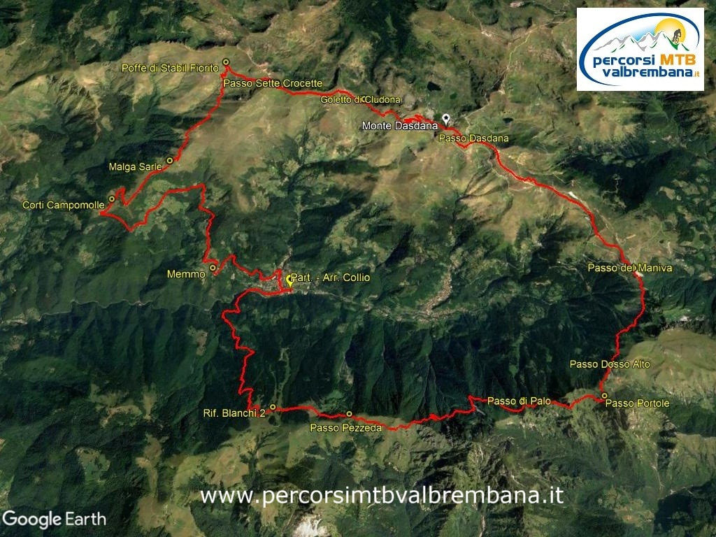
TEMPO DI PERCORRENZA: ore 5,45
|
St. Moritz - Padella Panorama TOUR
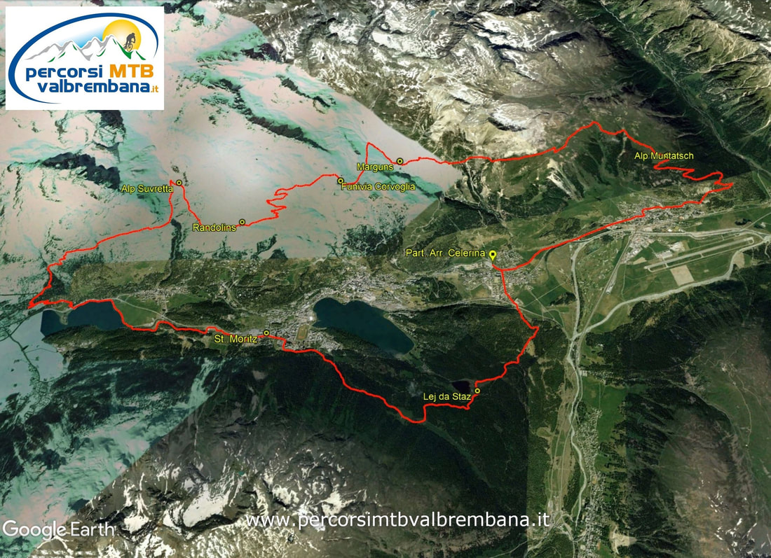
TEMPO DI PERCORRENZA: ore 3,40
|
Passo dell'Aprica - Val Belviso - Passo del Venerocolo
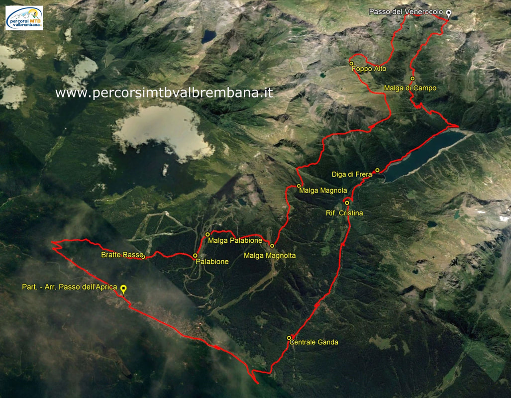
TEMPO DI PERCORRENZA: ore 5,50
|
Val Malenco - Rifugio Bosio - Alpe Piasci
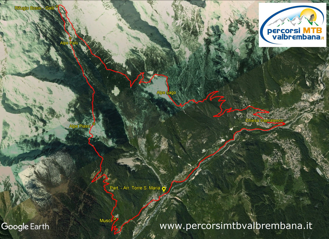
TEMPO DI PERCORRENZA: ore 4,00
|
Lago d'Idro - Forte Cima Ora - Monte Breda
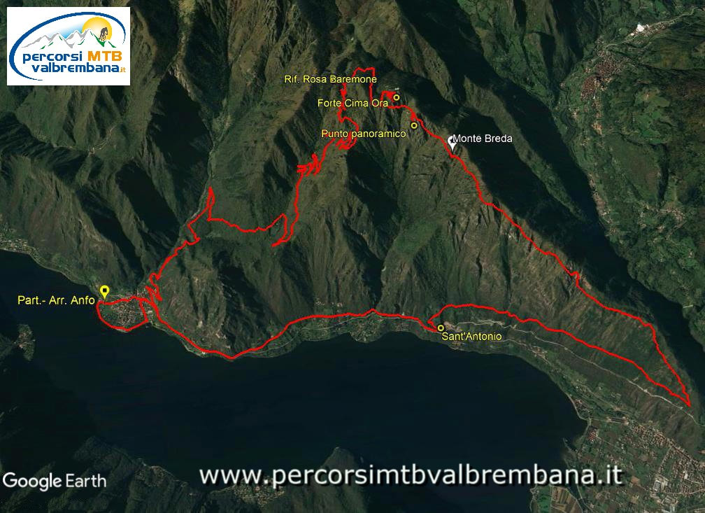
TEMPO DI PERCORRENZA: ore 4,00
|
Brusson - Rifugio Grand Tournalin - Champoluc

TEMPO DI PERCORRENZA: ore 5,30
|
Silvaplana - Fuorcla Surlej 2755 m - Val Roseg

TEMPO DI PERCORRENZA: ore 4,45
|
Bienno - Valdaione - Punta dell'Auccia 2212 m
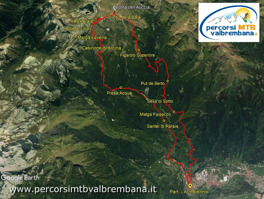
TEMPO DI PERCORRENZA: ore 6,15
|
Poggiridenti - Bocchetta di Mara - Dosso Liscio
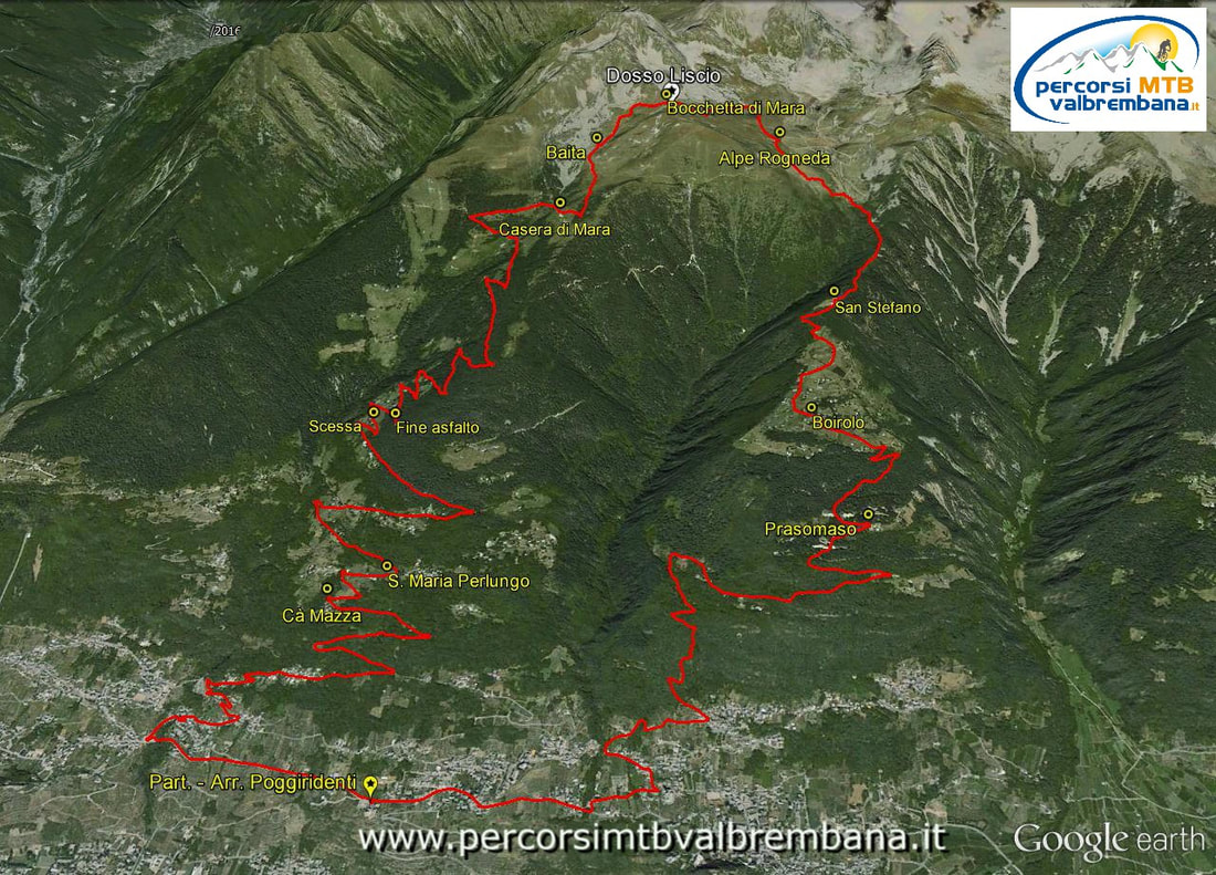
TEMPO DI PERCORRENZA: ore 4,45
|
Rifugio Bozzi - Laghi di Ercavallo - Passo delle Graole

TEMPO DI PERCORRENZA: ore 5,20
|
Piz Nair 3057 m da Celerina - St. Moritz
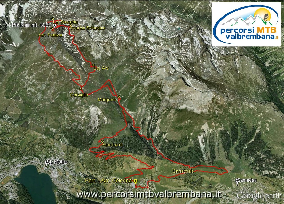
TEMPO DI PERCORRENZA: ore 4,30
|
Schilpario - Epolo - Malga di Voia - Clusorina - Azzone
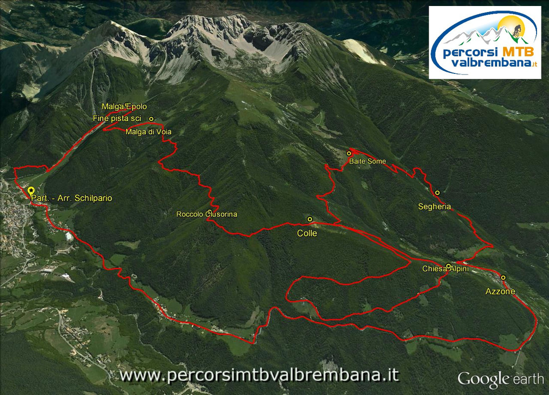
TEMPO DI PERCORRENZA: ore 4,00
|
Dalle porte di Lugano ai single track del Monte Bar
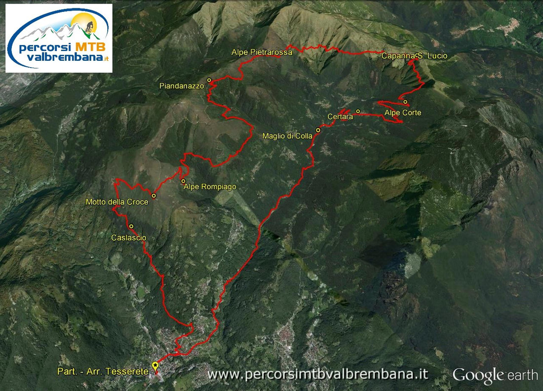
DISLIVELLO: 1361 m
|
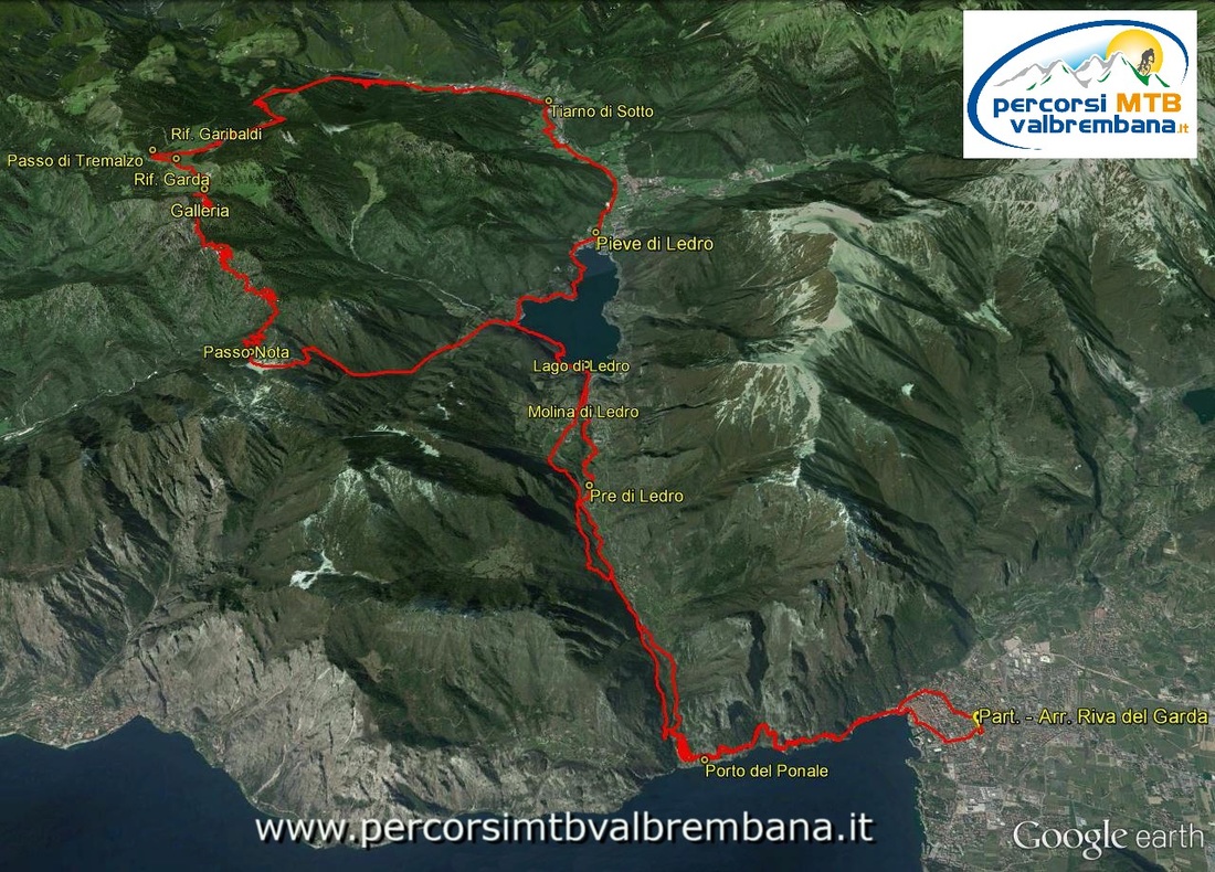
Riva del Garda - Lago di Ledro - Passo Tremalzo
|
Monte Bregagno dal Lago di Como

|
Alle pendici del Pizzo Camino
|
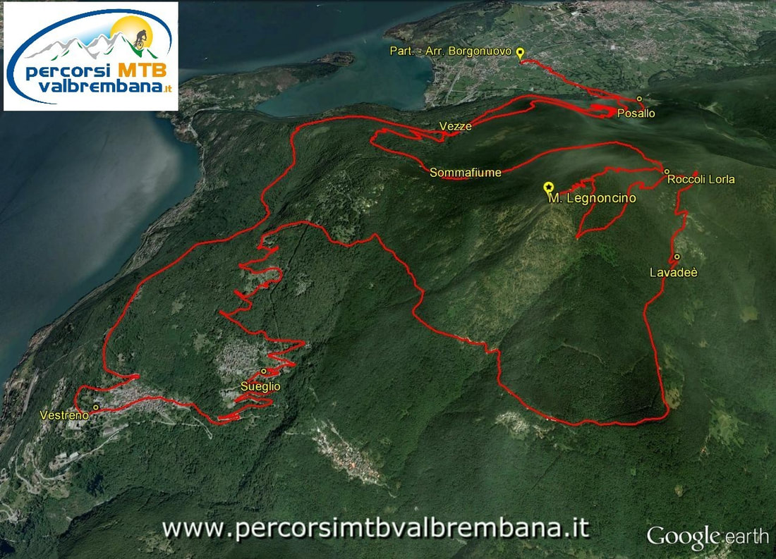
Monte Legnoncino da Colico
|
Santa Caterina Valfurva - Cima di Solda

|
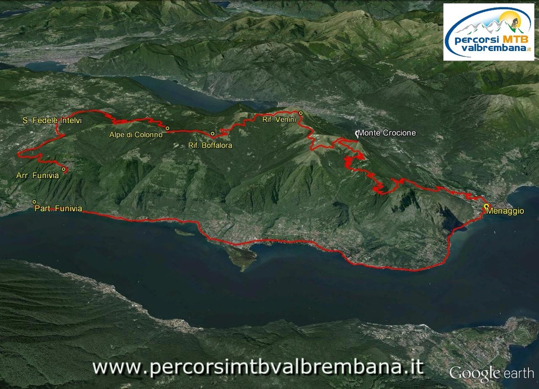
Menaggio - Rif. Venini - Monte Crocione
|
Gran Tour del Monte Chaberton

|
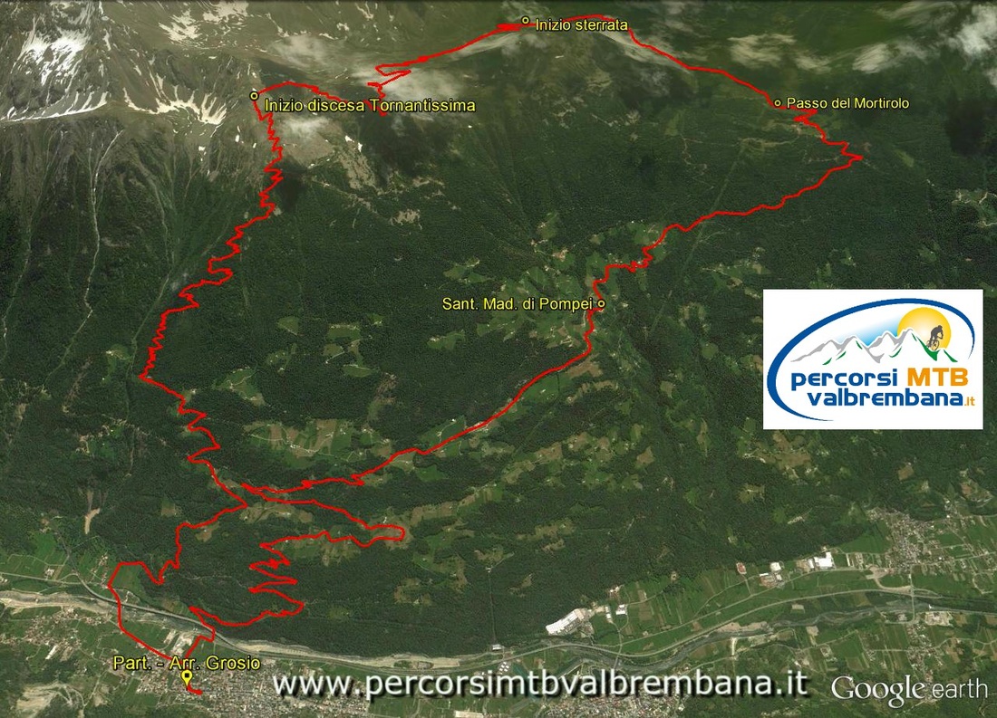
La Tornantissima
|
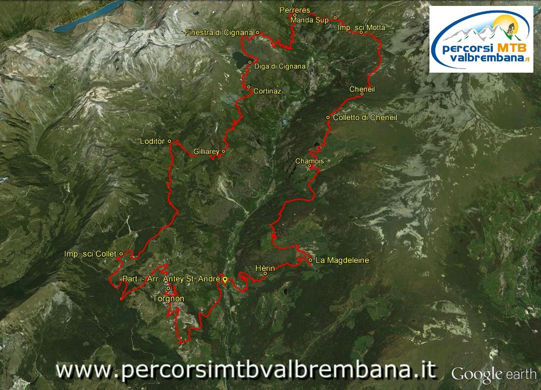
Grande Balconata del Cervino
|
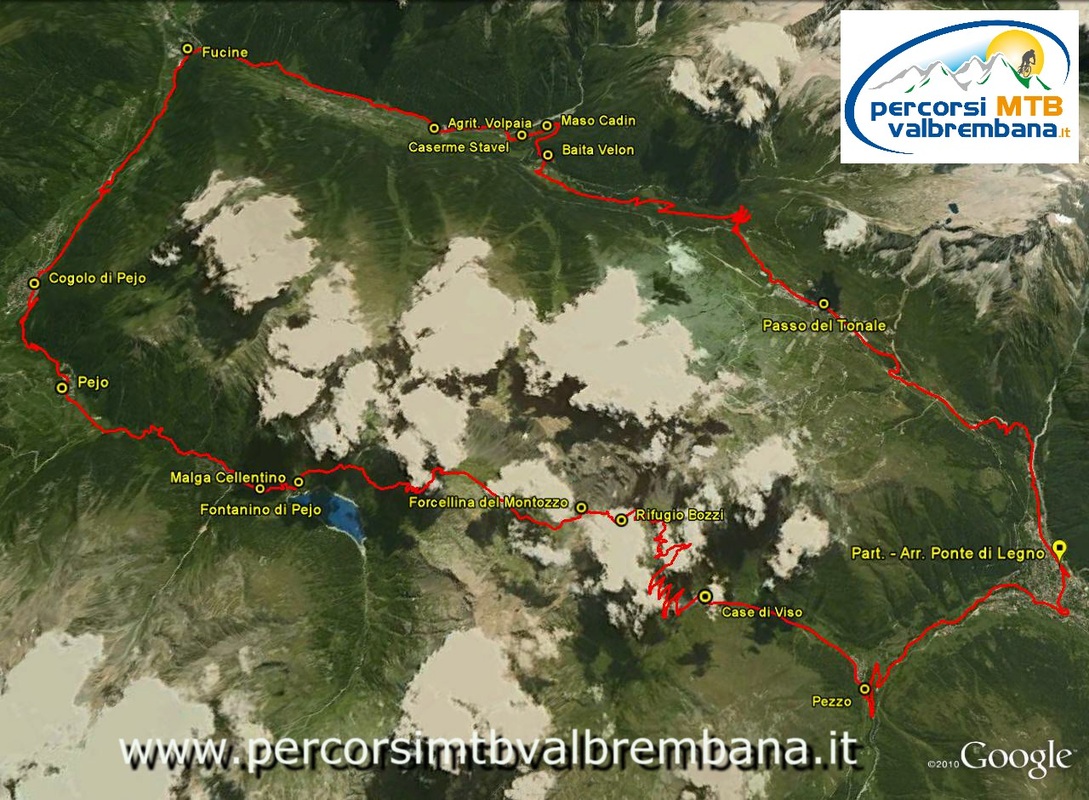
L'anello del Montozzo
|
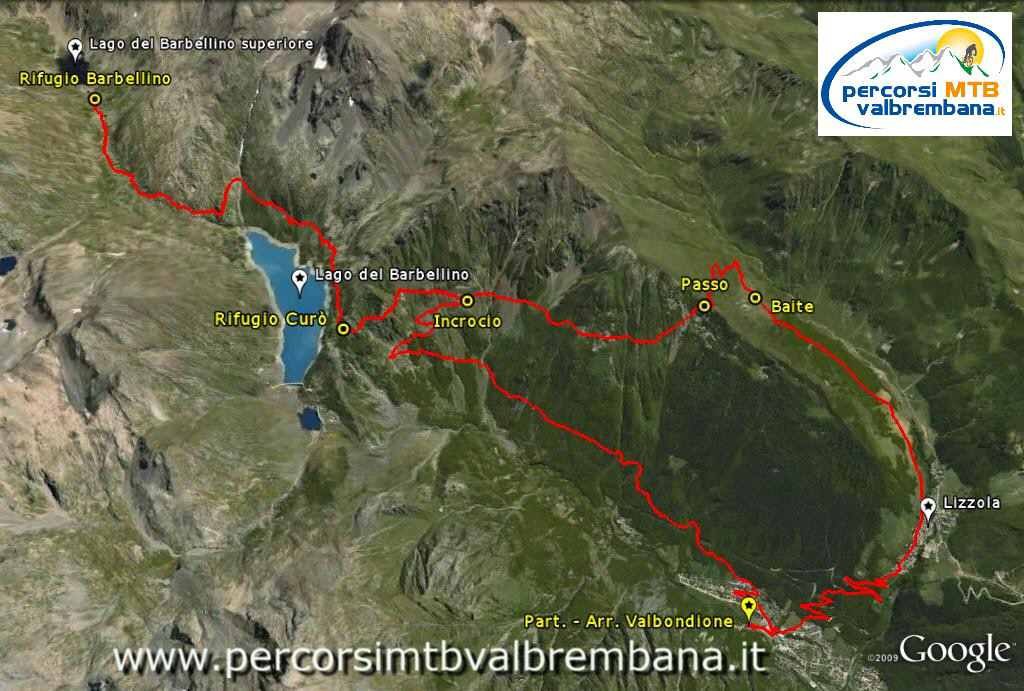
Rifugio Curo' - Lago Barbellino - Lizzola
|
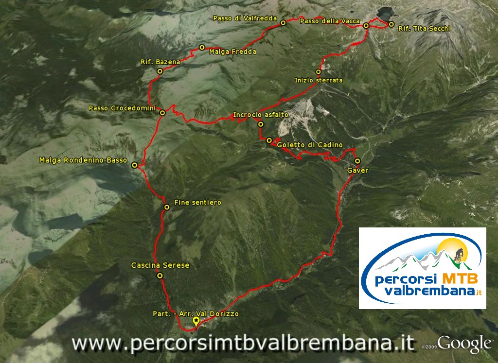
Lago della Vacca - Val Sanguinera
|
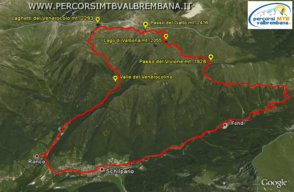
Passo del Gatto - Laghi di Venerocolo
|
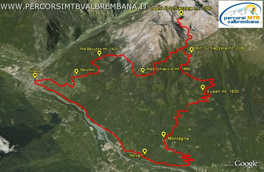
Tirano - Laghi di Schiazzera
|
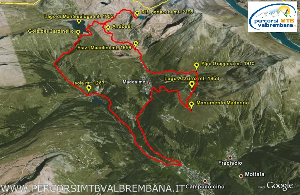
Rifugio Bertacchi - Gole del Cardinello
|
Cima Garibaldi - Bocchetta di Forcola

|